Posts

Showing posts from May, 2014

Ethno Linguistic Mapf of Ukraine - Minorities and Languages in Ukraine

Image
The map below might help to tell Ukraine's story. Ethnic Ukrainians Mostly Ukrainian-speaking, Predominantly Ukrainian-speaking, Mostly Russian-speaking, Predominantly Russian-speaking, Carpathian Ukrainians. Ethnic Russians and Other Ethnic Minorities Russians, Moldavians, Romanians , Hungarians, Bulgarians.

Map of The Hanseatic League - Main Trading Routes

Image
The Hanseatic League was a commercial and defensive confederation of merchant guilds and their market towns that dominated trade along the coast of Northern Europe. It stretched from the Baltic to the North Sea and inland between 13th and 17th centuries. Main cities on the route were; Novgorod, Riga, Danzig, Visby, Falsterbo, Lubeck, Hamburg, London, Brugge. Hansa Teutonica, Liga Hanseatica

Zeppelin - LZ 18

Image
The German Zeppelin LZ 18, at Berlin - Johannistal Airfield, 1913 This Zeppelin was used by The Imperial German Navy German Zeppelin What is LZ 18? What happened to LZ 18?

Island of Chios by Piri Reis

Image
This is a16th-century map of Chios, an island in Greece (Aegean Sea) on the Kitab-ı Bahriye (Book of Navigation) of Piri Reis (Ottoman admiral, geographer, and cartographer)

The Massacre of the Giustiniani at Chios

Image
The Massacre of the Giustiniani at Chios (dated firsy half of 18th Century), by Francesco Solimena, an Italian painter of the Baroque era. It's now in Museo di Capodimonte (Nastional Muzeum of Capodimonte, Naples, Italy)

Vertumnus

Image
Giuseppe Arcimboldo was an Italian painter and he produced this gorgeous painting, Vertumnus, in Milan (1590-1591). Vertumnus is Arcimboldo's most famous work. It is a portrait of the Holy Roman Emperor Rudolf II. Vertumnus is the Roman god of metamorphoses in nature and life.  At the moment the painting is part of the collection at Skokloster Castle in Sweden.

Royal Seal of Eric of Pomerania

Image
This is the Royal Seal of the first Nordic Kalmar Union King Eric of Pomerania.  Its dating 1398-1435 The Kalmar Union (Union of Calmar - Kalmarunionen - Unio Calmariensis) was a state that brought together the Scandinavian nations Norway, Denmark and Sweden from 1397 to 1523 Seal of Nordic Kalmar Union

Inuit Hunter and Wolf

Image
An Inuit hunter with killed grey wolf, 1914, near Schei Island, Greenland Published in 1944, The Wolves of North America, Vol. I

Map of Ancient Lower Egypt and Cities

Image
Lower Egypt has always been one of the most important corners of Mediterranean history. Ancient Egyptians, Greeks, Romans, Islam Empires and European Colonists did everything to control this area. Ancient names of the Lower Egypt cities Alexandria, Rosetta, Buto, Sais, Busiris, Tanis, Avaris, Heliopolis, Cairo, Memphis, Saqqara, Helwan, Dahshur, Meydum, Herakleopolis. Map by Jeff Dahl

Kanembu Warriors

Image
Warriors of Africa These were the warriors of The Kanem-Bornu Empire which was an empire that existed in modern Chad and Nigeria, Africa. Kanembu warriors and their mounted chief in an illustration from Heinrich Barth's Travels and Discoveries, Vol. III, 185

Woman With Horn - Human Horn

Image
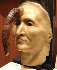
Madame Dimanche (Widow Sunday),  was a French woman lived in Paris in the early 19th century. A horn grew from her forehead in six years from the age of 76, a 24.9 cm (9.8")  before it was successfully removed by surgeon Br. Joseph Souberbeille. A wax model of her head is on display at the Mütter Museum, The College of Physicians of Philadelphia, US. Some other people with horn Zhang Ruifang, aged 101 (from China ), has grown a cutaneous horn on her forehead, it was called "Devil's Horns." it was only 6 centimeters in length. Another is forming on the opposite side of her forehead. Huang Yuanfan , aged 84 (living in Ziyuan, China)

Spread of the Black Death in Europe (1346–53)

Image
The Black Death spreads in Europe rapidly once it reaches to the shores of East Mediterranean. And it finds its way to Italy, France, Spain, Britain and Scandinavia. It was unstoppable . . (resulting in the deaths of an estimated 75 to 200 million people)  See another one: Map of The Black Death - Plague's Route to West

Regions of United States of America

Image
Map of the Regions of United States. THE WEST - Washington, Oregon, Montana, Idaho, Wyoming, Nevada, Utah , Colorado, California, Arizona, New Mexico, Hawaii, Alaska. THE MIDWEST - North Dakota, Minnesota, Wisconsin, South Dakota, Nebraska, Iowa, Illinois, Indiana, Ohio, Kansas, Missouri, Michigan. THE SOUTH - Oklahoma, Arkansas, Tennessee, Kentucky , West Virginia, Delaware, Maryland, Virginia, North Carolina, South Carolina, Georgia, Florida, Alabama, Mississippi, Louisiana, Texas. THE NORTH EAST - New Hampshire, Vermont, Massachussetts, New Jersey, Connecticut, Rhode Island, Maine, New York, Pennsylvania,

Map of The Black Death - Plague's Route to West

Image
Here you can see how the Black Death reached in Europe. Beginning in 1347 and continuing for a full five years, a devastating plague swept Europe ,  killed millions.. Plague's Route to Europe :Saray, Don River, Kaffa, Constantinople, Mediterranean Sea, Alexandria-Beirut, Balkans, Messina, Tunis, Sardinia, Pisa, Genoa, Toulouse, Garonne River, Bordeaux, Bristol, Weymouth, Norh Sea.   See another one: Spread of the Black Death in Europe (1346–53)

Sir Francis Drake in Cartagena 1585

Image
Italian cartographer Giovanni Battista Boazio's illustration for Sir Francis Drake when he arrived in Cartagena, 1585

Love - How long would you wait for love? - Would romance ever die?

Image
He was a hopeless romantic. He did not need dating, flirting or looking for women around. He has that secret attraction in his eyes and soul.. Love always found him easily; but the one he wanted always hated him.. Ricardo Lighthouse : "Why are you so successful with women?" Florentino Ariza : "Um... because they see in me someone... guilty. In need of love. Someone who will not harm them. Hmmph. My heart has more rooms than a whore house, Ricardo." Ricardo Lighthouse : "What number are you on now?" Florentino Ariza : "Prepare yourself for a shock. I'm on number 622." Ricardo Lighthouse : "Impossible." Florentino Ariza: "I speak the truth - 622."

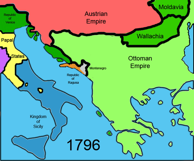
Balkans 1796 - Boundaries of Balkans in 1796

Image
This is how Balkans were shared by Austrian Empire, Moldavia, Wallachia, Ottomans Empire , Montenegro, Rupiblic of Raguso and Republic of Venice in 1796.

Map of Crusades and Cities on Routes

Image
Historical Map of The Crusades, Routes and The Cities The First Crusade  (1096-1099) started from two different main gathering locations. First one was in France . They marched through Rome, Bari, Greece, Constantinople (Istanbul) and Antioch. The second was in Germany.  The Second Crusade (1147-1150)   started in north of Italy . They marched through Austria, Hungary, Belgrade, Sofia and  Constantinople. They changed the direction from that point. Nobody was expecting it though.  The Third Crusade (1189-1192) started from Marseille and Genoa. They sailed the entire Mediterranean Sea (through Sicily, Rhodes, Cyprus and arrived in Jerusalem. The Fourth Crusade (1202-1204) the planned route was a bit complicated. They had to change it several times.  Some of the old cities on the route with modern names are: Dyrrachion ( Albania ), Adrianople ( Edirne ), Nicaea ( Iznik ) , Dorylaion (  Şarhöyük, Eskisehir ),  Antioch ( Antakya ),  Edesa ( Urfa ) , Acre ( Akko or Akka ) Rela

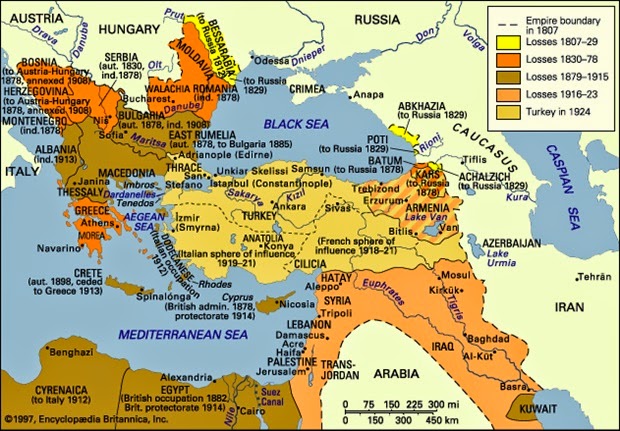
Detailed Map of The Decline of the Ottoman Empire

Image
Losses of Ottoman Empire between 1800-1923. Bessarabia to Russia, 1812 - Kars to Russia, 1878 -  Cyrenaica to Italy, 1912 - East Rumelia to Bulgaria, 1885 - Walachia, 1878 - Albania 1913 - Egypt, 1882 - Cyprus to British Admin. 1878

Popular posts from this blog

Sibirya

Map of Crusades and Cities on Routes

Map of Roman Empire 300 A.D

Hunger Map of Europe 1918

Search This Blog