Posts
Showing posts from July, 2014
Popular posts from this blog
Sibirya
Sibirya Nerede. Sibirya dünyanın neresinde? Kulağımıza her söylendiğinde, bir yerlerde her okuduğumuzda hep en uzaklardaymış , en ulaşılmaz topraklardaymış gibi gelir.. Türklerin ana yurdu der bazıları, kimileri da Sovyetler zamanının sürgün yeri olarak hatırlar sadece.. Orta Rusya'daki Ural Dağları'ndan doğuda Büyük Okyanus'a kadar uzanan toprakların bulunduğu yere Sibirya denir. Kazakistan'ın ve Moğolistan'ın kuzey bölgeleri ile ve Orta Asya'nın bir kısmı da Sibirya'ya dahildir. Türkiye'nin yaklaşık 19 katı genişliğinde bir alandır burası. Sibirya'nın haritadaki yerine bakalım şimdide Batı Sibirya ve Doğu Sibirya şeklinde coğrafi bölgeler olarak ikiye ayrılır.
Map of Crusades and Cities on Routes
Historical Map of The Crusades, Routes and The Cities The First Crusade (1096-1099) started from two different main gathering locations. First one was in France . They marched through Rome, Bari, Greece, Constantinople (Istanbul) and Antioch. The second was in Germany. The Second Crusade (1147-1150) started in north of Italy . They marched through Austria, Hungary, Belgrade, Sofia and Constantinople. They changed the direction from that point. Nobody was expecting it though. The Third Crusade (1189-1192) started from Marseille and Genoa. They sailed the entire Mediterranean Sea (through Sicily, Rhodes, Cyprus and arrived in Jerusalem. The Fourth Crusade (1202-1204) the planned route was a bit complicated. They had to change it several times. Some of the old cities on the route with modern names are: Dyrrachion ( Albania ), Adrianople ( Edirne ), Nicaea ( Iznik ) , Dorylaion ( Şarhöyük, Eskisehir ), Antioch ( Antakya ), Ed...
Map of Roman Empire 300 A.D
This is Roman Empire after 285 A.D The Empire was divided East-West. Western Provinces : Diocese of Britain, Diocese of Gaul, Diocese of Spain, Diocese of Italy , Africa and Rome. East Roman's Provinces : Diocese of Dacia, Dioese of Thrace, Egypt , Asia, Diocese of Pontus and Macedonia Ancient Circle Stones in Scotland. The Callanish Stones are an arrangement of standing stones placed in a cruciform pattern with a central stone circle. They were erected in the late Neolithic era, and were a focus for ritual activity during the Bronze Age. They are near the village of Callanish on the west coast of Lewis in the Outer Hebrides, Scotland
Hunger Map of Europe 1918
Hunger Map of Europe. Have you ever seen Europe in hunger before? This map shows the hunger levels for the Europe in 1918. It was in an article published first in the newspaper, The New York Times Current History Magazine for the April-May-June 1919 99 Years later.. No more Hunger in Europe; Now the young Europeans are enjoying a good life.. like in this bar
HISTORICAL PAINTINGS
HISTORIC IMAGES
- American foreign aids 2015
- Chicago's Dark History
- Costumes of Sardinia 1880
- Edmonton's Silent History
- Electric Chair of Tennessee
- Faroe Stamps Viking Voyages
- Fijian Women in 1935
- Inuit Hunter and Wolf
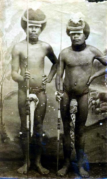
- Kanak Warriors
- Kanembu Warriors
- Members of Council of Lithuania 1917
- The Depression in Canada
- The Last Emir of Bukhara
- Woman With Horn
- Zeppelin ZL 18
- Africa 2014
- Anatolia 1325
- Ancient Lower Egypt and Cities
- Balkans 1796
- Detailed Map of The Decline of the Ottoman Empire
- Famous Crusader Quotes
- Greek Colonization of Western Asia Minor
- Hunger Level for Europe 1918
- Kanembu Warriors
- Lithuanian - Polish 1466
- Magna Germania and Romans
- Sir Francis Drake in Cartagena 1585
Historical Maps Archive
-
-
-
-
-
-
- King Kong 1933 - The First King Kong - A Classic B...
- Is Barro Blanco Dam a big danger for Ngäbe-Buglé t...
- Map of Veins of Human Body in 13th Century
- Kanak Warriors with penis gourds and spears
- Fijian women in 1935 - Fiji Women in Black and Whi...
- Princes of Orange - William I, Maurice and Frederi...
-
-
-
-
-
-