Posts

Showing posts from 2021

Detroit's Bison Skull Mountain

Image
Bison Skulls in Detroit, 1892 This is a nn amazing photograph from 1892 of a pile of American bison skulls in Detroit, Michigan, waiting to be ground for fertiliser or charcoal. What Happened To American Bisons in 1800's At the beginning of the century (1800's), tens of millions of bison roamed North America. Pioneers and European settlers slaughtered an estimated 50 million bison during the 19th century. This overhunting was in part motivated by the U.S. government's desire to limit the range and power of indigenous plains Indians whose diets and cultures depended on the buffalo herds.The overhunting of the bison reduced their population to hundreds. Railroads were advertising "hunting by rail", where trains encountered large herds alongside or crossing the tracks. Men aboard fired from the train's roof or windows, leaving countless animals to rot where they died. Today; As of July 2015, an estimated 4,900 bison lived in Yellowstone National Park , the larges...

Historical Map of Battle of the River Berre

Image
Map of the Attacks of Frankish Forces Against Muslim Army, River Berre, in South of France. Battle of the River Berre Year : 737 Location : South of France Belligerents : Frankish forces under the command of Charles Martel Arab forces under the command of Uqba ibn al-Hayyay. Result : Frankish victory. What Happened During The Battle Charles advances to meet the Muslim forces on the banks of the Berre River. Upon Ibn Khaled's death, the Franks overwhelm the Muslim army, putting it to the flight. While attempting to fleet their boats, the Muslims are cut down by Frankish forces in the stagnant waters.

New Mexico Racial Breakdown of Population

Image
Races and Ethnics of New Mexico When we carefully look at the historical map of New Mexico , we see it as a Mexican, or let's say Spanish land ( It was called New Spain in the history). And today, it's part of the United Staes of America but the demography doesn't say so. Firstly, New Mexico is a majority-minority state, which means population is composed of less than 50% non-Hispanic whites. According to 2015 figures, 48% of the total population was Hispanic or Latino. This is the highest of any state in the US. New Mexico Racial Breakdown of Population New Mexican Spanish The majority of Hispanics in NW claim to be descendants of Spanish colonists who settled here from 16th to 18th centuries. Many of them speak New Mexican Spanish at home. After Alaska New Mexico also has the second largest Native American Indian population in the country. What Languages Did Native Peoples of Texas Speak?

A French Settlement in Texas

Image
An Unknown French Colony Settlement in Texas Have you ever heard about " Field of Asylum " ? 1818, 20 French Bonapartist soldiers who had fought in Europe during Napoleonic Wars arrived in US and found a settlement in Texas ( along the Trinity River ). It was called " Champ d'Asile " which means "Field of Asylum" in English. It was a very short-lived settlement, built in January and abandoned July 1818. This is the map of this historic settlement. It doesn't look large but it was well established and built. What Languages Did Native Peoples of Texas Speak?

What Languages Did Native Peoples of Texas Speak

Image
Ethnolinguistic Map of Native Texas Indians When Europeans arrived in North America there were over 500 different languages spoken by American Indians. In Texas as its shown on this linguistic distribution map, seven different languages were spoken when the colonisation of southern territories started in 1500. Wars between the white men and natives caused mass migrations and after 300 years, there were new languages in Texas. Language Map of Texas 1500-1800 Texas Native Languages on The Map Uto-Aztecan ( South West Culture ) Athapascan ( Prehorse Plains ) Caddoan ( South East Culture ) Coahuiltecan ( Western Gulf Coast Culture ) Shoshonean ( Northern Plains ) Siouan ( Osage ) Tunican ( Attacapan ) Research by Texas Historical Survey Committee, 1972 Published by The University of Texas at Austin, Bureau of Business Research An Unknown French Colony Settlement in Texas

Islamic Countries Map

Image
Map of Muslim Countries and Distribution of Sunni and Shia  There are over 70 countries in the world where Islam is the predominantly practiced religion. As a major religion, Islam  is the fastest-spreading religion in the world. 31% of Muslims live in South Asia and 15% in sub-Saharan Africa. The number of muslims also growing in Europe and North America rapidly. Source: CIA The World Factbook

Ethnic Map of Cyprus Before The Turkish Invasion

Image
Ethnic Distribution of Cyprus, 1973. Turkish and Greek Areas This map shows where Greeks and Turks were predominately living in Cyprus in 1973 , just before The Turkish Invasion. British Sovereign Bases are shown the map as well. By 2020, estimated numbers of Turkish population in Cyprus is 300,000 and there are about 900,000 Greeks living on the island as well. 

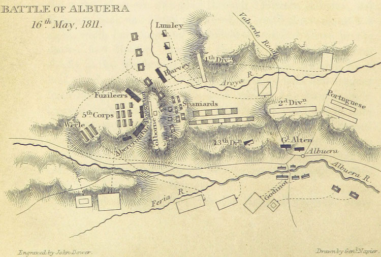
Map of The Battle of Albuera

Image
A historical map of the positions of the forces at The Battle of Albuera, 1811 One of the most important and game changer battles of the Peninsular War was definitely The Battle of Albuera . French were trying to control Iberian Peninsula and Spain, the United Kingdom and Portugal tried to stop them.  Map was engraved by William Francis Patrick in his book "History of the War in the Peninsula and in the South of France, from the Year 1807 to the Year 1814"  Source; British Library

Adana Vilayeti Haritası 1892

Image
1892 Yılında Çizilmiş Bir Adana Vilayet Haritası Burada gördüğünüz harita ilke kez 1800'lu yıllarda Osmanlı Devleti Düyûn-ı Umûmiye (iç ve dış borçlarını denetleyen kurum) genel sekreteri olarak görev yapmış olan ünlü Fransız araştırmacı ve coğrafyacı Vital Cuinet tarafı ndan yayınlanan kısaca Türkiye'nin idari coğrafyası olarak bilinen kitabında yayınlandı. 150 yıllık bu harita Adana Vilayeti , merkez, sancaklar ve nahiyeleri çok net bir şekilde göstermektedir. Adana, sancaklar ne nahiyeler harita

Historical Map of South Eastern Europe 1648

Image
South Eastern Europe 1648 This historical map of South Eastern Europe shows us the boundaries of Ottoman Empire between 1648 and 1739 in Balkans. The yellow line is the Austro-Turkish frontier fixed by the Treaty of Karlowitz 26 January 1699 Ottoman Empire and Balkans 1648

Conquests of Alexander The Great

Image
Historical Map of Conquests of Alexander The Great in Asia and Middle East. When he started marching towards south east, nobody could imagine how far she would go. Alexander the Great reached to the farest corners of that eras world and conquered the most powerful lands of Asia and Middle East. Battles and Conquests of Alexander The Great Alexander's Battles on the Route This map also shows the places of the most critical moments of his conquests which were The Battle of the Granicus, The Battle of Gaugamela, Issus and The Basttle of Hydaspes. Source: U.S Military Academy Department of History

Illinois Police Force 1920s

Image
The Police Force of Illinois, 1920 This historical image shows us how the Police forces looked like in 1920's Illinois, US. These policemen were in Springfield, the capital of the state.

Map of Europe 1815

Image
Historical Map of Europe 1815 After The Congress of Vienna  1815 there was one of the most important international diplomatic conferences in European history, making the new European political order after the French Emperor Napoleon lost his power; The Congress of Vienna. Europe Map 1815 Participants of the congress were; Austria, Russia, Prusya, France, Great Britain, Spain, Portugal, Sweden, Denmark, Switzerland, Kingdom of Sardinia, Papal States, Republic of Genoa, Grand Duchy of Tuscany. Here you can read the Final Act of the Congress of Vienna/General Treaty as full text.

Hungarian Jews at Auschwitz

Image
Gas Chamber or Work What we see in this photograph is the Nazi officials selecting Hungarian Jews to send some of them to gas chambers in Auschwitz and the rest to work, in 1944, during the final phase of the Holocaust.  The photograph is part of the collection known as the Auschwitz Album, which was donated to Yad Vashem by Lili Jacob, a survivor, who found it in the Mittelbau-Dora concentration camp in 1945.

The Cost of World War II

Image
How many people died in World War II? When we see these numbers, it's impossible to defend a war. A war is the worst of enemy of human and the world. The horrific facts of the war is terrible. Number of Deaths, Displaced People, Tanks, Aircrafts, Artillery From September 1939 to September 1945 Deaths in Battles 15 Million Wounded in Battles 25 Million Civilian Deaths 25 Million People Displaced 16 Million Aircraft Production 916 Thousand Tan Production 280 Thousand Total Cost of War 1.29 Trillion

Historic Map of Britain 800 AD

Image
A historical map of the British Isles, 802 AD. In 800's Britain was still under invasion of Northern Germanic tribes.  British Isles were shared by the States of the Angles, States of the Saxons, State of the Jutes, and the States of the native Britons Scots and Picts. Related Maps : Britain 1600 Years Ago ,  Britain 1250-1450

Gothic Raids to Greece, Balkans, Black Sea and Anatolia in the 3rd Century

Image
Did Goths try to invade Greece, Turkey, Balkans and Cyprus? The Goths were another warrior Germanic people who played a big role of creating the Medieval Europe. The Goths tried to invade the South East Europe in 3rd century and most of their raids were successful. They attacked almost all the important ports of Black Sea, Greece, Aegean Sea and all the way down to Cyprus. On this historical map we see the directions of the Gothic raids to the east of Roman Empire in 300 AD. Source; "Gothic raids in the 3rd century' Wikipedia, 4.0 International Places on the map: ESCITIA - Scythia ( Ukraine, Crimea, South West Russia ) PAFLAGONIA - The area between Istanbul and Trabzon ( Turkey ) PONTO - Pontus ( Eastern Black Sea Region of Turkey )

Map of Eastern Themes of Byzantine Empire in AD 950

Image
Historical map of the development of the Byzantine Themes. Byzantine Districts or Themes were the main administrative divisions of the middle Byzantine Empire. After the Muslims occupied a large part of the eastern of the empire and Slavic invasions from north and west, old provincial system was not working anymore to defend the provinces. So this new Theme idea was brought to create a stronger military base districts where the army and civilians run the administration together. Themes of Byzantine Empire in Anatolia There were 17 themata in Anatolia in AD 950 Chaldia, Koloneia, Mesopotamia, Sebastea and Lycandus in the East and North East, Armeniacs, Paphlagonia, Optimatoi and Bucellarians in North, Charsianon, Cappadocia and Anatolic in the Middle, Seleucia and Cibyrrhaeots in South, Opsikion, Thracesians and Samos in West

Historical Map of Occupation of Greece At WW2

Image
Did you know Greece was occupied by Nazi Germany, Italy and Bulgaria at the World War II between 1941-1944. It was called "Axis Occupation of Greece". On this historical map of Greece; Red areas were under German occupation, Green areas were under Bulgarian, And the blue parts were under Italian occupation Map "Triple Occupation of Greece" from Wikipedia , distributed under a CC-BY 2.0 license.

Map of the Ocean and Globe in 1492

Image
Have you ever seen a map of the world that shows only Africa and Asia?   How have the people of 14th century seen the world, oceans and the globe? Here the Oceanic area on the famous The Erdapfel, of Martin Behaim. He was a German cartographer. He served Portugal as an adviser in matters of navigation and participated in a voyage to West Africa. He was the creator of the world's oldest surviving globe, which he produced for the Imperial City of Nuremberg in 1492. As you see on the map, that time America was not known yet by Europeans so he  has believed the opposite shore of Africa was Asia. And Japan was in the middle.

The Deportation of the Acadians

Image
One of the most known paintings which tells us about The Deportation of the Acadians , by Henri Beau (1900) After The Battle of Fort Beauséjour, in 1758, thousands of Acadians were transported to France

Map of India 1765 to 1805

Image
This map of India in 1765 and 1805  This detailed historical map is showing British East India Company Territories in pink. As you see, the East India Company has expanded its territories more than double in 40 years.  The English East India Company was founded in 1600 in London.

Popular posts from this blog

Sibirya

Map of Crusades and Cities on Routes

Map of Roman Empire 300 A.D

Hunger Map of Europe 1918

Search This Blog