Posts

Showing posts from March, 2021

Islamic Countries Map

Image
Map of Muslim Countries and Distribution of Sunni and Shia  There are over 70 countries in the world where Islam is the predominantly practiced religion. As a major religion, Islam  is the fastest-spreading religion in the world. 31% of Muslims live in South Asia and 15% in sub-Saharan Africa. The number of muslims also growing in Europe and North America rapidly. Source: CIA The World Factbook

Ethnic Map of Cyprus Before The Turkish Invasion

Image
Ethnic Distribution of Cyprus, 1973. Turkish and Greek Areas This map shows where Greeks and Turks were predominately living in Cyprus in 1973 , just before The Turkish Invasion. British Sovereign Bases are shown the map as well. By 2020, estimated numbers of Turkish population in Cyprus is 300,000 and there are about 900,000 Greeks living on the island as well. 

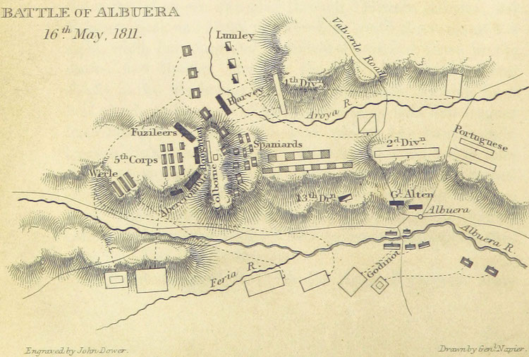
Map of The Battle of Albuera

Image
A historical map of the positions of the forces at The Battle of Albuera, 1811 One of the most important and game changer battles of the Peninsular War was definitely The Battle of Albuera . French were trying to control Iberian Peninsula and Spain, the United Kingdom and Portugal tried to stop them.  Map was engraved by William Francis Patrick in his book "History of the War in the Peninsula and in the South of France, from the Year 1807 to the Year 1814"  Source; British Library

Adana Vilayeti Haritası 1892

Image
1892 Yılında Çizilmiş Bir Adana Vilayet Haritası Burada gördüğünüz harita ilke kez 1800'lu yıllarda Osmanlı Devleti Düyûn-ı Umûmiye (iç ve dış borçlarını denetleyen kurum) genel sekreteri olarak görev yapmış olan ünlü Fransız araştırmacı ve coğrafyacı Vital Cuinet tarafı ndan yayınlanan kısaca Türkiye'nin idari coğrafyası olarak bilinen kitabında yayınlandı. 150 yıllık bu harita Adana Vilayeti , merkez, sancaklar ve nahiyeleri çok net bir şekilde göstermektedir. Adana, sancaklar ne nahiyeler harita

Historical Map of South Eastern Europe 1648

Image
South Eastern Europe 1648 This historical map of South Eastern Europe shows us the boundaries of Ottoman Empire between 1648 and 1739 in Balkans. The yellow line is the Austro-Turkish frontier fixed by the Treaty of Karlowitz 26 January 1699 Ottoman Empire and Balkans 1648

Conquests of Alexander The Great

Image
Historical Map of Conquests of Alexander The Great in Asia and Middle East. When he started marching towards south east, nobody could imagine how far she would go. Alexander the Great reached to the farest corners of that eras world and conquered the most powerful lands of Asia and Middle East. Battles and Conquests of Alexander The Great Alexander's Battles on the Route This map also shows the places of the most critical moments of his conquests which were The Battle of the Granicus, The Battle of Gaugamela, Issus and The Basttle of Hydaspes. Source: U.S Military Academy Department of History

Illinois Police Force 1920s

Image
The Police Force of Illinois, 1920 This historical image shows us how the Police forces looked like in 1920's Illinois, US. These policemen were in Springfield, the capital of the state.

Map of Europe 1815

Image
Historical Map of Europe 1815 After The Congress of Vienna  1815 there was one of the most important international diplomatic conferences in European history, making the new European political order after the French Emperor Napoleon lost his power; The Congress of Vienna. Europe Map 1815 Participants of the congress were; Austria, Russia, Prusya, France, Great Britain, Spain, Portugal, Sweden, Denmark, Switzerland, Kingdom of Sardinia, Papal States, Republic of Genoa, Grand Duchy of Tuscany. Here you can read the Final Act of the Congress of Vienna/General Treaty as full text.

Hungarian Jews at Auschwitz

Image
Gas Chamber or Work What we see in this photograph is the Nazi officials selecting Hungarian Jews to send some of them to gas chambers in Auschwitz and the rest to work, in 1944, during the final phase of the Holocaust.  The photograph is part of the collection known as the Auschwitz Album, which was donated to Yad Vashem by Lili Jacob, a survivor, who found it in the Mittelbau-Dora concentration camp in 1945.

The Cost of World War II

Image
How many people died in World War II? When we see these numbers, it's impossible to defend a war. A war is the worst of enemy of human and the world. The horrific facts of the war is terrible. Number of Deaths, Displaced People, Tanks, Aircrafts, Artillery From September 1939 to September 1945 Deaths in Battles 15 Million Wounded in Battles 25 Million Civilian Deaths 25 Million People Displaced 16 Million Aircraft Production 916 Thousand Tan Production 280 Thousand Total Cost of War 1.29 Trillion

Historic Map of Britain 800 AD

Image
A historical map of the British Isles, 802 AD. In 800's Britain was still under invasion of Northern Germanic tribes.  British Isles were shared by the States of the Angles, States of the Saxons, State of the Jutes, and the States of the native Britons Scots and Picts. Related Maps : Britain 1600 Years Ago ,  Britain 1250-1450

Gothic Raids to Greece, Balkans, Black Sea and Anatolia in the 3rd Century

Image
Did Goths try to invade Greece, Turkey, Balkans and Cyprus? The Goths were another warrior Germanic people who played a big role of creating the Medieval Europe. The Goths tried to invade the South East Europe in 3rd century and most of their raids were successful. They attacked almost all the important ports of Black Sea, Greece, Aegean Sea and all the way down to Cyprus. On this historical map we see the directions of the Gothic raids to the east of Roman Empire in 300 AD. Source; "Gothic raids in the 3rd century' Wikipedia, 4.0 International Places on the map: ESCITIA - Scythia ( Ukraine, Crimea, South West Russia ) PAFLAGONIA - The area between Istanbul and Trabzon ( Turkey ) PONTO - Pontus ( Eastern Black Sea Region of Turkey )

Map of Eastern Themes of Byzantine Empire in AD 950

Image
Historical map of the development of the Byzantine Themes. Byzantine Districts or Themes were the main administrative divisions of the middle Byzantine Empire. After the Muslims occupied a large part of the eastern of the empire and Slavic invasions from north and west, old provincial system was not working anymore to defend the provinces. So this new Theme idea was brought to create a stronger military base districts where the army and civilians run the administration together. Themes of Byzantine Empire in Anatolia There were 17 themata in Anatolia in AD 950 Chaldia, Koloneia, Mesopotamia, Sebastea and Lycandus in the East and North East, Armeniacs, Paphlagonia, Optimatoi and Bucellarians in North, Charsianon, Cappadocia and Anatolic in the Middle, Seleucia and Cibyrrhaeots in South, Opsikion, Thracesians and Samos in West

Historical Map of Occupation of Greece At WW2

Image
Did you know Greece was occupied by Nazi Germany, Italy and Bulgaria at the World War II between 1941-1944. It was called "Axis Occupation of Greece". On this historical map of Greece; Red areas were under German occupation, Green areas were under Bulgarian, And the blue parts were under Italian occupation Map "Triple Occupation of Greece" from Wikipedia , distributed under a CC-BY 2.0 license.

Popular posts from this blog

Sibirya

Map of Crusades and Cities on Routes

Map of Roman Empire 300 A.D

Hunger Map of Europe 1918

Search This Blog