Posts

Showing posts from 2013

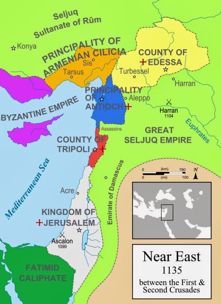
Historical Near East Map - Near East in 1135
Image
Between First and Second Crusades there were too many states, principalities, empires around Near East. In this detailed historical map you can see where the Principality of Armenian Cilicia, County of Edessa, Principality of Antioch, Great Seljuq Empire, Emirate of Damascus, Kingdom of Jarusalem, Fatimid Caliphate, County of Tripoli, Byzantine Empire, Seljuq Sultane of Rum were in 1135 AD

Famous Crusader Quotes - Turkish Emir and Rainald Porchet

One of The Most Interesting Quotes of the Crusaders at The Siege of Antioch 1098 The Siege of Antioch was one of the most unforgettable battles of First Crusade. This interesting dialogue has been happened between Turkish Emir and Crusader Knight Rainald Porchet . "On another day the Turks led to the top of an Antiochian wall a noble knight, Rainald Porchet, whom they had imprisoned in a foul dungeon. They then told him that he should inquire from the Christian pilgrims how much they would pay for his ransom before he lost his head. From the heights of the wall Rainald addressed the leaders: "My lords, it matters not if I die, and I pray you, my brothers, that you pay no ransom for me. But be certain in the faith of Christ and the Holy Sepulchre that God is with you and shall be forever. You have slain all the leaders and the bravest men of Antioch; namely, twelve emirs and fifteen thousand noblemen, and no one remains to give battle with you or to defend the city." ...

Roman empire map greatest extent - Grestest borders of Roman Empire

Image
This is the map of Roman Empire around AD 117 when it has its greatest extent. Roman Empire was all over Mediterranean and North Africa, Arab Peninsula, Anatolia, Balkans, Sout and South West Europe.

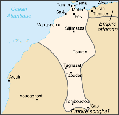
Saadian Empire Map 1590 - Historical Map of The Saadi dynasty of Morocco

Image
Between 1555 and 1659, there was a very poweful empire in todays Morroco; Saadian Empire or as their common mame The Saadi dynasty. They ruled Morocco from south to the north. This map shows extent of the Saadian Empire during the reign of Ahmad al-Mansur . Its dated 1690. As we see on the map; Tombouctou, Taghazat, Taudeni, Sıjilmasa, Melila, Fes, Marrakech were some of the main towns of the Saadian Empire . Eflatun Pınar, A Hittite Sacred Spring. An ancient pool in Turkey, aboyt 4000 years old!

Map of Magna Germania and Roman Empire

Image
Magna Germania (Germania Libera) in 2nd Century BC.  As you seen on this historical map, Magna Germania was the larger territory east of the Rhine. Germania was inhabited by different tribes, most of them Germanic but also some Celtic, proto-Slavic, Baltic and Scythian peoples.

Kingdom of Urartu Historical Map

Image
Urartu was an Iron Age kingdomi around Van Lake and Mount Ararat (oday Eastern Turkey) This is Kingdom of Uratu between 9th–6th centuries BC. Some of the most famous Urartu cities are shown on the map; Arsazku, Nihiriani, Meyshta, Argishtinhinele. Aniastania, Tushpah. Kievan Rus' trade routes map 8th and 11th Centuries

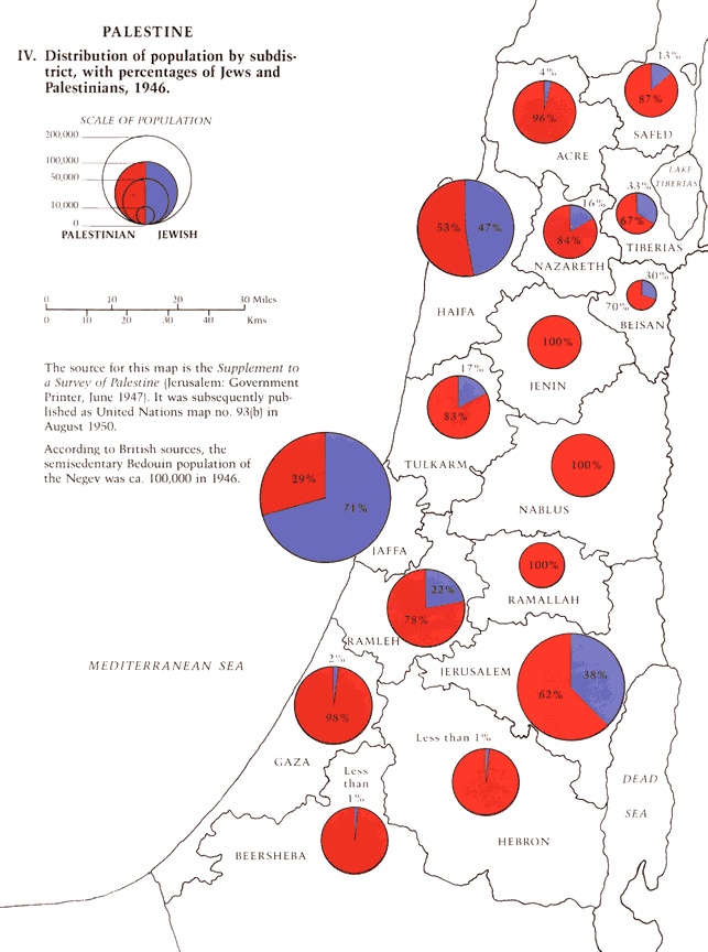
Population Map of Palestinian and Jewish by 1946

Image
This map shows the distribution of population (Palestinian and Jewish) by subdistricts, 1946. It was published as United Nations Map no.93 in August 1950 Palestian Red Jewish Blue

Newfoundland 1775 Map - An Old Map of Newfoundland by Captain Cook

Image
From 1763 to 1767 James Cook made a detailed survey of the coasts of Newfoundland and southern Labrador (Canada) and published this map . This is a general chart of the island of Newfoundland Surveyed by Cook and M. Lane, and presented to the King in 1775.

Kievan Rus' trade routes map 8th and 11th Centuries

Image
This is major Kievan Rus' trade routes map, between 8th and 11th centuries. The red route was The Volga trade road. And the purple route was from the Vikings to the Greeks. The orange routes are the other roads to other places.

Kievan Rus 11th Century Map

Image
Kievan Rus' was a Medieval state in Europe, between late 9th and 13th centuries. It's also known as "Land of the Rus" Kievan Rus' was officially founded by Prince Oleg about 880. And it was ended by Mongol invasions.

A Black Death painting - The Triumph of Death

Image
The Black Death -Plague, The Great Plague- has killed millions of people in Europe, Middle East, North Africa and Eurasia for centuries.. and it has caused mass migrations and political changes.. and it has also changed the maps, too. (see Spread of Black Death map) A famous Dutch artist, Pieter Bruegel the Elder's  The Triumph of Death is one of the best painting about this horrible disaster. The Triump of Death was painted in1562. It's now in Madrid (Museo del Prado)

Popular posts from this blog

Sibirya

Map of Crusades and Cities on Routes

Map of Roman Empire 300 A.D

Hunger Map of Europe 1918

Search This Blog