Posts

Showing posts from January, 2013

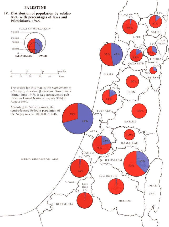
Population Map of Palestinian and Jewish by 1946

Image
This map shows the distribution of population (Palestinian and Jewish) by subdistricts, 1946. It was published as United Nations Map no.93 in August 1950 Palestian Red Jewish Blue

Newfoundland 1775 Map - An Old Map of Newfoundland by Captain Cook

Image
From 1763 to 1767 James Cook made a detailed survey of the coasts of Newfoundland and southern Labrador (Canada) and published this map . This is a general chart of the island of Newfoundland Surveyed by Cook and M. Lane, and presented to the King in 1775.

Kievan Rus' trade routes map 8th and 11th Centuries

Image
This is major Kievan Rus' trade routes map, between 8th and 11th centuries. The red route was The Volga trade road. And the purple route was from the Vikings to the Greeks. The orange routes are the other roads to other places.

Kievan Rus 11th Century Map

Image
Kievan Rus' was a Medieval state in Europe, between late 9th and 13th centuries. It's also known as "Land of the Rus" Kievan Rus' was officially founded by Prince Oleg about 880. And it was ended by Mongol invasions.

A Black Death painting - The Triumph of Death

Image
The Black Death -Plague, The Great Plague- has killed millions of people in Europe, Middle East, North Africa and Eurasia for centuries.. and it has caused mass migrations and political changes.. and it has also changed the maps, too. (see Spread of Black Death map) A famous Dutch artist, Pieter Bruegel the Elder's  The Triumph of Death is one of the best painting about this horrible disaster. The Triump of Death was painted in1562. It's now in Madrid (Museo del Prado)
Popular posts from this blog

Sibirya

Map of Crusades and Cities on Routes

Map of Roman Empire 300 A.D

Hunger Map of Europe 1918

Search This Blog