Posts

Showing posts from March, 2014

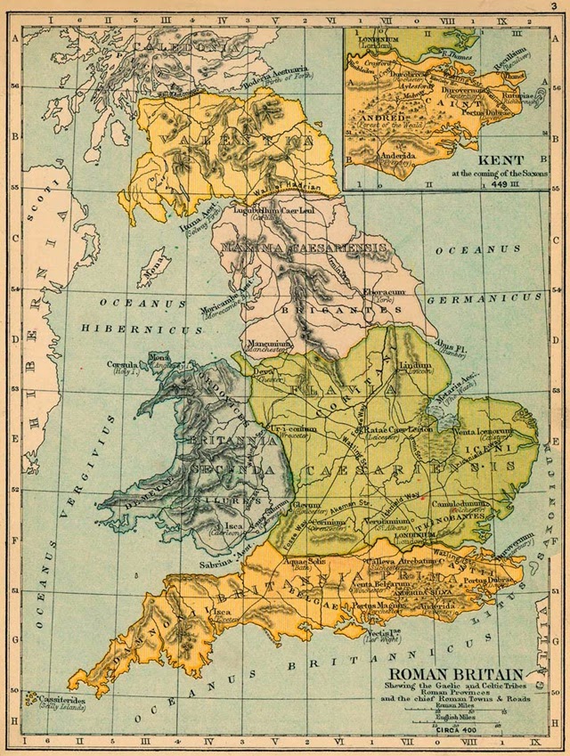
Britain Map 4th Century - Britain 1600 Years Ago
Image
A detailed Map of Roman Britain 400 A.D On this 4th century Britain map,    you will see Gaelic and Celtic Tribes, Roman Provinces, Towns and Roads. Britannia Prima, Ceasariensis, Coritani, Brigantes, Maxima Ceasariensis, Britannia Secunda, Ordovices, Valentia, Caledonia.

Ethnic Groups in Balkans and Eastern Europe

Image
Map of the Ethnic Groups in Eastern Europe and Balkans (except Greece) Poles, Czechs, Slovaks, Hungarians, Romanians, Slovenes, Croats , Serbs, Muslims, Bulgarians, Montenegrins, Albanians, Macedonians, Turks.

Soviet Union Nationalities Map 1986

Image
Which Nationalities were within Soviet Union in 1982? Map of Soviets 1982 illustration Courtesy of the University of Texas Libraries, The University of Texas at Austin

Soviet Union Population Map 1979

Image
Density Map of Soviet Union Rural and Urban Population Data Based on 1979 Census Illustration: Courtesy of the University of Texas Libraries, The University of Texas at Austin

Islamic World in 750 - Map of the First A Hundred Years of Islam

Image
Map of the Muslim world and the Caliphate in 750. On this historical map you can see ; Conquest of the Arabs up to the death of Mohammed, 632 Conquest of the Arabs under first three Caliphs,632-656 Conquest of the Arabs under the Umayyad Caliphs, 651-750 How did Mediterranean, Europe, Arab Peninsula and North Africa look like in A.D 750?

Distribution of Christians in India in 1901

Image
How many Christians were living in South Asia in 1901? In this map you can see where the number of Christians in -today's- India, Bangladesh, Nepal, South Asian Islands. As we see in the details,120 years ago, there were about 2.923.000 Christians in South Asia. Source: University of Chicago

Map of Asia in 1762

Image
How did Asia look like in 1762? What countries, states and empires were in Asia 250 hundred ears ago? This great work was made by a Frenchman, Jean Janvier and published in his Atlas-book "Atlas moderne ou collection de cartes sur toutes les parties du globe terrestre par plusieurs auteurs."

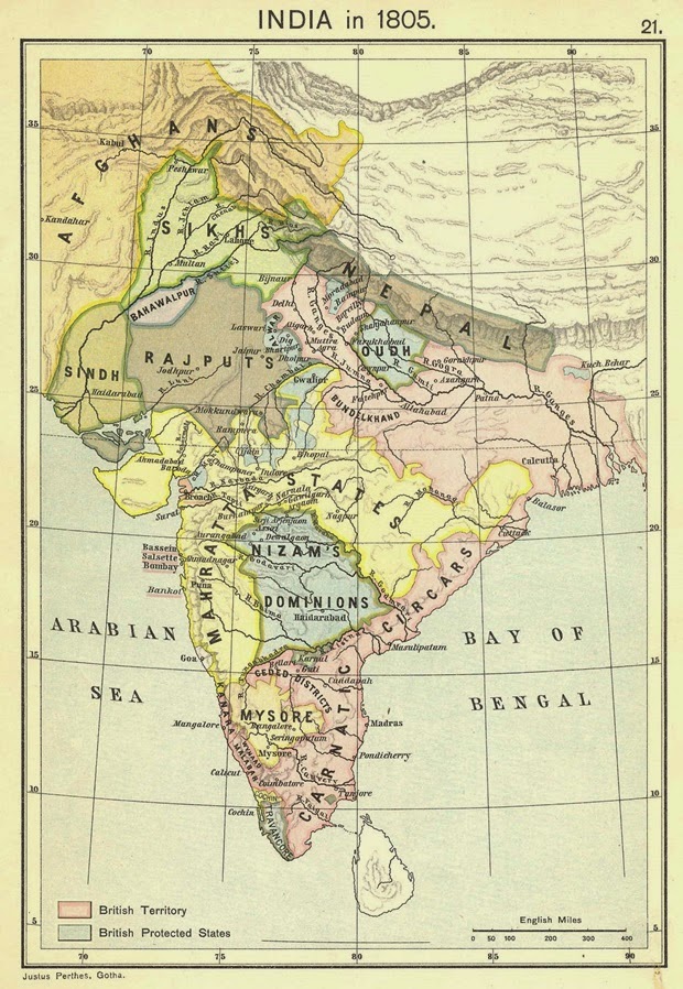
India in 1805 - A detailed Map of India in early 1800's

Image
What was India like 200 hundred years ago? This is a detailed map of India in 1805. It shows the British Territories and the British Protected States in India as well. Areas in this map: Sikhs, Sindh, Rajputs, Oudh, Bundelkhand, Mahratta States, Nizam's Dominions, Carnatic Circars, Mysore, Travancore

The Kingdom of Vaspourakan 908-1021

Image
Vaspourakan, meaning the "noble land" or "land of princes". Located in what is now called eastern Turkey and northwestern Iran, the region is considered to be the cradle of Armenian civilization. Van, Artamet,  Hadamakert, Ostan, Ketsan and Khizan were the main cities of The Kingdom of Vaspourakan. Photo: Armenica.org

Greek Colonization of Western Asia Minor 11th-18th Centuries B.C

Image
A detailed map of Greek settlements in western Asia Minor, during the Greek Dark Age (or Geometric Age) 11th-8th cent. BC. Dorians colonise the southern lands, Ionians colonise the centre area and Aeolians colonise the nothern part of Asia Minor. -Assos, Pitane, Aegae , Temnos, Adramytttion, Larissa and Mytilene are main Aeolian cities. -Smyrna, Teos, Colophon, Ephesus, Myus, Milet, Magnesia, Samos Island and Chios  are main Ionian cities, -Halikarnassos, Kos , Knidos, Lindos are main Dorian cities. Map by Alexikoua - Wikipedia (thanks very much for this great work)

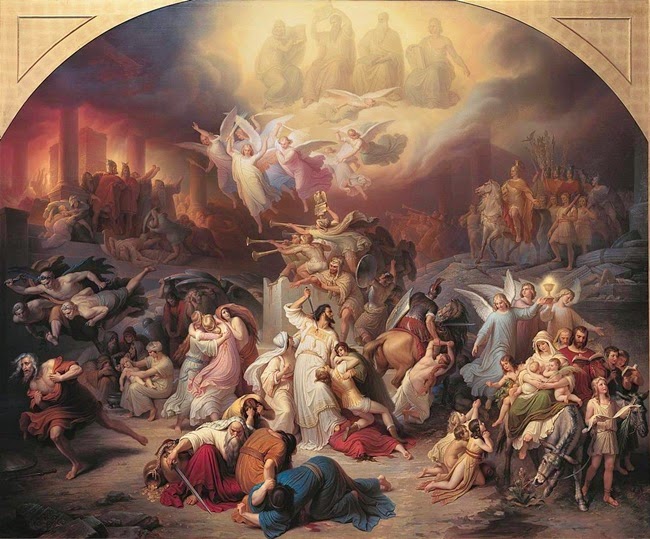
Destruction of Jerusalem

Image
 Titus destroying Jerusalem also known as "The Destruction of Jerusalem" by Wilhelm von Kaulbach. Oil on Canvas, 1846

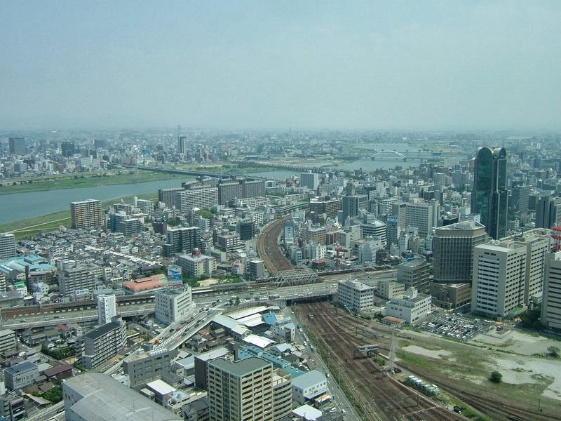
Osaka City Panoramic View

Image
Osaka, Japan.. View From Umeda Sky Building Photo by  https://www.flickr.com/chaojikazu/

Tuva Cumhuriyeti

Image
Tuva Cumhuriyeti Haritası.   Kırmızı renkli yer

Murdering Grand Duke Mikhail Yaroslavich

Image
Grand Duke Mikhail Yaroslavich Being Murdered at Golden Horde. An interesting illustration by Russian graphic artist Boris Artemyevich Chorikov. (Dated circa 1836) What do you know about the Voyages of Chinese explorer Admiral Zheng He? 

Sibirya

Image
Sibirya Nerede. Sibirya dünyanın neresinde? Kulağımıza her söylendiğinde, bir yerlerde her okuduğumuzda hep en uzaklardaymış , en ulaşılmaz topraklardaymış gibi gelir.. Türklerin ana yurdu der bazıları, kimileri da Sovyetler zamanının sürgün yeri olarak hatırlar sadece.. Orta Rusya'daki Ural Dağları'ndan doğuda Büyük Okyanus'a kadar uzanan toprakların bulunduğu yere Sibirya denir. Kazakistan'ın ve  Moğolistan'ın kuzey bölgeleri ile ve Orta Asya'nın bir kısmı da Sibirya'ya dahildir. Türkiye'nin yaklaşık 19 katı genişliğinde bir alandır burası.  Sibirya'nın haritadaki yerine bakalım şimdide Batı Sibirya ve Doğu Sibirya şeklinde coğrafi bölgeler olarak ikiye ayrılır.

Voyages of Zheng He - Chinese Voyages to Africa

Image
Voyages of Chinese explorer Admiral Zheng He between 1405 - 1422 According to medieval Chinese sources, Zheng He commanded seven expeditions. The 1405 expedition consisted of 27,800 men and a fleet of 62 treasure ships supported by approximately 190 smaller ships. Some of the ships were over 300 feet long and 150 feet wide, the largest being 440 feet long and 186 feet across, capable of carrying 1,000 men. The crew included sailors, clerks, interpreters, soldiers, artisans, medical men and meteorologists. An Illustration of Battle Between Chinese and Mongols China The Cake Of The Kings and Emperors

Popular posts from this blog

Sibirya

Map of Crusades and Cities on Routes

Map of Roman Empire 300 A.D

Hunger Map of Europe 1918

Search This Blog