Posts

Showing posts from 2020

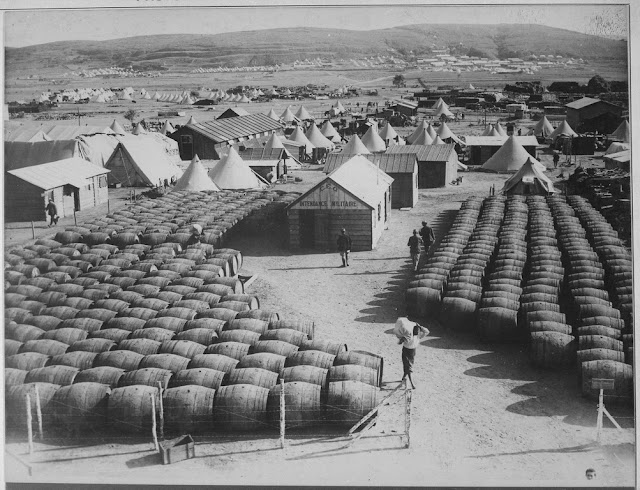
French Military Wine Store in Lemnos Island

Image
French hospital and Wine Store in Lemnos Island  Aegean Sea during Dardanelles Campaign 1919

Gavur Nedir? Gavur İnsanı Keser Mi?

Image
Gavur korkunç bir insan mıdır? Gavurlar gelirse ne olur?   Köye gelen gavurlardan neden çok korktular? Tarsus'un Beylice Köyü'nde 1959 yılında yaşanmış gerçek bir olayı o günü yaşayan bir kişi anlatıyor. Çocukların gözünden köye gelen gavurlar. Anlatan: Yusuf Kula (Postacı)

İzmir Bayrağı

Image
İzmir Bayrağı. İzmir'in Bayrağı Nasıldı. İzmir Bayrağı Hangi Simgelere Sahip. İzmir Bayrağı Hangi Renklerden Oluşuyor. Yunanlılar 1920'de İzmir'i işgal ettiklerinde Izmir ve bölgesi icin bu bayrağı kullanmak istemişlerdi. Ortadaki haç Yunan haçını, aradaki hilaller de bölgedeki müslümanları temsil ediyor.

Slave Branding

Image
Slave Branding in America 1853 Branding was sometimes used to mark recaptured runaway slaves to help the locals easily identify the runaway. Slave owners used extreme punishments to stop flight, or escape. They would often brand the slaves' palms, shoulders, buttocks, or cheeks with a branding iron. Source: New York Public Library, " Five hundred thousand strokes for freedom ; a series of anti-slavery tracts, of which half a million are now first issued by the friends of the Negro." by Armistead, Wilson, 1819?-1868 and " Picture of slavery in the United States of America . " by Bourne, George, 1780-1845
Turkish Seljuk Sultanate in 1243

Image
Map of the Anatolian Seljuk Sultanate in 1243 This map also shows Expansion of the Sultanate between 1100–1240. Also known as The Sultanate of Rum, Sultanate of Iconium, Rum Sultanate, Anatolian Seljuk State or Anatolian Seljuk Sultanate.

Mongol Archers 1300

Image
How did Mongol archers look like in 1300's? Rashid-al-Din Hamadani shows us Mongo soldiers in 12th century in Compendium of Chronicles ( Jami' al-tawarikh )

Illustration of Battle Between Chinese and Mongols 1211

Image
One of best illustrations of the battles between Mongols & Chinese in 12th century. An amazing illustration from Rashid-al-Din Hamadani's " Compendium of Chronicles " ( Jami' al-tawarikh ) which was one of the grandest projects of the Ilkhanate period.

The Route of Ten Thousand

Image
The Route of Ten Thousand, The Great Marching Between 401 and 399 BC, the Ten Thousand ( Greek heavy troops ) marched across Anatolia, fought the Battle of Cunaxa and then marched back to Greece.  This is the route Route of the great marching. It was recorded by Xenophon , one of their leaders, in his work Anabasis . It starts in Sardes ( today near Salihli in Turkey ) in West Anatolia and ends in Chrysopolis ( today Üsküdar, an Asian suburb of Istanbul )

Map of Ancient Mesopotamia and Egypt 1450 BC

Image
A detailed map of Ancient Mesopotamia 1450 BC The borders of Hittite Empire, Mitanni State, Assyria, Babylonia and Egypt . You can also see the major cities of that times; Nineveh, Assur, Susa, Babylon, Tyre, Troy, Thebes, Nubia and Memphis.

How did the Sea People invade the Aegean Sea and Eastern Mediterranean at the end of the Late Bronze Age?

Image
A detailed map of Map of the Sea People invasions in the Aegean Sea and Eastern Mediterranean at the end of the Late Bronze Age. Inland invasions and sea invasions. Destruction of Troy 1190-1180 BC Destruction of Mycenae 1210-1200 BC Destruction of Ugarit 1192-1175 BC Source: © D. Kaniewski 

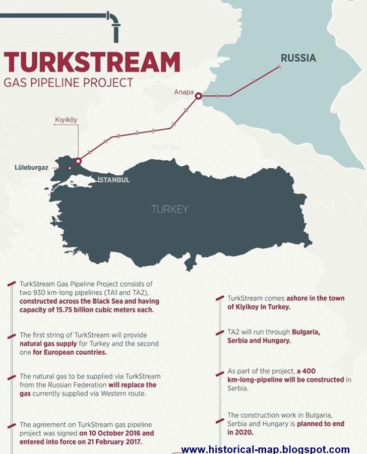
TurkStream Map - TurkStream Pipeline

Image
The Route of TurkStream Where is TurkStream?  TurkStream starts from Anapa in Russia's Krasnodar Region, crossing the Black Sea to the receiving terminal at Kıyıköy. in Kırklareli Province at northwestern Turkey. The second line will continue from Kıyıköy to Malkoçlar on the Turkey–Bulgaria border, where it will be connected to the existing Trans-Balkan pipeline system . And from there to Bulgaria, Serbia , Hungary, Slovakia and Austria.

Popular posts from this blog

Sibirya

Map of Crusades and Cities on Routes

Map of Roman Empire 300 A.D

Hunger Map of Europe 1918

Search This Blog